
Borehole geophysics is the process of measuring, recording, and analyzing the physical properties in water wells or test holes. Tools, or probes, that measure certain features are lowered into the borehole to collect continuous or point data. A geophysical log is a graphic display of the information. Various logs are collected from each borehole to take advantage of their combined nature. We can learn more cumulatively by the analysis of a suite of logs as a group than by the study of the same records individually.
What is borehole geophysics used for?
Borehole geophysics is used in water resources and environmental investigations to obtain information on:
- Well construction
- Rock lithology and fractures
- Porosity
- Permeability
- Water quality
What makes up a geophysical logging system?
A geophysical logging system consists of probes, cable and winches, power and data processing modules, and data recording units. A computer controls a state-of-the-art logging system and assists in real-time viewing of the measurements. Some systems can collect multiple logs with one pass of the probe.
Why do we perform borehole geophysical well logging?
Borehole geophysical logging can provide in-depth information that is critical in gaining a better understanding of subsurface conditions. This is important for many water resources and environmental investigations. Geophysical logs provide empirical, continuous, and in-situ data and generally sample a larger volume than retrieving well cuttings or coring samples alone.
- Delineation of hydrogeologic units
The varying hydrogeologic and stratigraphic units found in the subsurface at a given site display a wide range of characteristics to store and transmit groundwater and contaminants.
Borehole geophysics provides a highly efficient means to determine the character and thickness of the various hydrogeologic units penetrated by wells and test holes. This information is essential for wellfield design, including the proper placement of water well casing and screens and for assessing and remediating groundwater contamination.
- Defining groundwater quality
The quality of groundwater is sometimes highly variable. Human-made or natural sources may cause groundwater contamination. Integration of borehole geophysics with water-quality sampling provides a complete picture, whether the objective is to install a new water supply well or remediate a contaminated aquifer.
- Determination of existing water well construction and well conditions
Water wells are considered access points to a groundwater aquifer. Knowledge of their construction and condition is essential whether they are used for groundwater supply, monitoring, or remediation. Borehole geophysics provides a rapid evaluation of the location and condition of the casing and screen of a well.
The common borehole geophysics tools and how are they used
Geophysical logs include single-point resistance, spontaneous potential, gamma, normal resistivity, fluid resistivity, electromagnetic induction, caliper, temperature, flowmeter, video, and acoustic televiewer.
Single-point resistance is an electric log that measures the potential differences due to the flow of electric current in and adjacent to a borehole. The resistance is obtained from an electrical ground at land surface. These logs are especially useful for identifying lithologic changes in carbonates where the rocks do not contain enough radioactive material to cause changes in the gamma log response. The electric logs can also be used to derive porosity within the sediment or rock surrounding the borehole. Penetration distance into the surrounding lithologic material varies with the diameter of the borehole and the type of electric logging tool in use. Porous rocks provide electrical flow pathways through the groundwater contained in their interconnected pores and register as low resistivity on electric logs. Conversely, nonporous rocks resist electrical current flow and register as high resistivity.
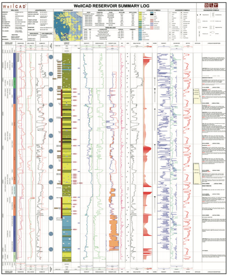
Spontaneous-potential logs record naturally occurring potentials or voltages developed between the borehole fluid and the surrounding rock and fluids. Spontaneous-potential logs are useful in the determination of lithology and water quality. Collection of spontaneous-potential data is limited to water or mud-filled open holes (uncased wells or boreholes).
Gamma logs record the quantity of naturally occurring gamma radiation emitted from the units surrounding the borehole. Clay- and shale-bearing rocks typically emit relatively high gamma radiation. Generally, carbonates contain relatively low levels of radioactive material and, consequently, the gamma log response is relatively small.
Normal resistivity well logs record the electrical resistivity of the borehole conditions and surrounding rocks and water. Bed thickness, borehole diameter, and borehole fluid affect normal resistivity logs. These logs are only collected in water or mud-filled open holes.
Fluid-resistivity logs measure and record the electric resistivity of water in a borehole. The nature, quantity, and distribution of the water contained in the bed controls the electrical conductivity of the bed. Changes in fluid resistivity may reflect differences in dissolved-solids concentration of water. These logs are useful for determining water-bearing zones and identifying vertical water flow in the borehole.
Electromagnetic-induction logs measure the electrical conductivity or resistivity of the sediments, rocks, and water surrounding the open borehole. Porosity, permeability, and clay content influence the electrical conductivity and resistivity of the rocks. The concentration of dissolved solids in the water within the formation also affects these logs. The electromagnetic-induction probe is specifically designed to maximize vertical resolution and depth of investigation and to minimize the effects of the borehole fluid.
Caliper logs are a physical measurement of the borehole diameter. Changes in borehole diameter reveal information on the construction of an existing well, such as the condition of the well casing or screen. In open boreholes, the caliper can help identify the drilling-bit size as well as fracturing or caving in at the borehole wall. Borehole diameter commonly affects log response. Therefore, the caliper log is useful in the analysis of other geophysical logs, including interpretation of flowmeter logs.
Temperature logs measure the water temperature in a well or borehole. Temperature logs are useful for defining water-bearing zones and identifying vertical flow in the borehole between depths of differing hydraulic head penetrated by wells. Borehole flow between different zones is indicated by temperature gradients that are less than the regional geothermal gradient, which is around 1 degree Fahrenheit per 100 feet of depth.
Flowmeter logs record the rate and direction of vertical flow in the borehole. Borehole-flow rates are calculated from downhole-velocity measurements along with the borehole diameter that is recorded by the caliper log. Flowmeter logs can be collected under non-pumping or pumping conditions.
Video logs record a video image of the borehole. In addition to being recorded to disk, the optical image is typically viewed in real time on a monitor. Well construction, water level, cascading water from above the water level, lithology and fractures, and changes in borehole water quality (suspended particles, chemical precipitates, and gas) can be viewed directly with the video system.
Acoustic-televiewer logs record a magnetically oriented, photographic image of the acoustic reflectivity of the borehole wall. Televiewer logs indicate the location and strike and dip of fractures and lithologic contacts. The collection of televiewer imagery is limited to water or mud-filled open holes.
Recent advances in borehole geophysics for groundwater studies
Detailed information on subsurface conditions is necessary for the development and management of groundwater resources and the assessment and remediation of contaminated sites. Borehole geophysics provides a means for the collection of this information.
Recent advances in methods and equipment have significantly increased the ability of geoscientists to obtain subsurface information in investigations through borehole geophysical techniques.
- Portable geophysical loggers
Portable geophysical loggers specifically designed for groundwater applications are available. The logging equipment is PC-based and has menu-driven software for the collection, display, and analysis of digital log data. Combining probes enables us to collect multiple geophysical parameters with a single logging run, thereby significantly increasing the efficiency of the site work.
- Electromagnetic-induction
Electromagnetic-induction logs replaced normal-resistivity logging in the oil patch a long time ago. Induction probes are designed specifically for small-diameter monitoring wells. Induction logs can be collected in water, air, and mud-filled holes and through PVC casing. Significant factors that affect induction-log response in sand-and-gravel aquifers are the concentration of dissolved solids in the groundwater and the silt and clay content of the aquifer. Induction logs, typically run in combination with gamma ray logs, are used to identify subsurface lithology and areas of electrically conductive contamination such as landfill leachate and saltwater intrusion into a freshwater zone.
- High-Resolution flowmeters
High-resolution flowmeters that utilize heat-pulse and electromagnetic methods can measure relatively small vertical water flow rates in boreholes and wells. Conventional impeller flowmeters that are commonly used in groundwater investigations have a lower measurement limit of about 2 meters per minute. High-resolution flowmeters have relatively lower measurement limits, typically of less than 0.03 feet per minute. These meters can be used to measure borehole flow under non-pumping as well as active pumping conditions. Borehole flow measurements made under natural conditions can help to define transmissive fractures and other permeable zones; they also are helpful in the interpretation of fluid-conductivity logs and borehole water-quality information. Borehole flow measurements made under pumped conditions can be used to develop hydraulic conductivity profiles of aquifers.
- Video cameras
Video cameras are regularly used in groundwater investigations to inspect the condition of water well casings and screens. They can also be used to directly view lithologic texture, grain size, and color; water levels and cascading water; and bedrock fractures. Video logs can be obtained in clear water and above the water level. Video logging systems are magnetically oriented and provide a 360-degree digital image of the borehole wall.
- Acoustic televiewers
Acoustic televiewers provide a magnetically oriented, 360-degree, photograph-like image of the acoustic reflectivity of the borehole wall. These tools have been used in the oil industry for many years and are being used increasingly in groundwater investigations. Televiewer logs, which indicate acoustic transit-time and reflected amplitude, can be obtained from water or mud-filled boreholes. The newest digital televiewer systems allow rapid, interactive determination of fracture orientations.
- Borehole radar
Borehole radar is an exciting method that enables us to detect fracture zones at distances as far as 30 feet or more from the borehole in electrically resistive rocks. Borehole radar measurements can be obtained in a single borehole with the transmitter and receiver in same borehole, or by cross-hole tomography with the transmitter and receiver in separate open boreholes. Single-hole, directional radar is utilized to identify the orientation and location of fracture zones. Cross-hole tomography is used to delineate fracture zones that are between boreholes. The migration of a saline tracer through fracture zones can be observed by borehole radar.
Let’s wrap it up!
So there’s a look at borehole geophysics — soup to nuts. We hope this information is helpful to understanding just what borehole geophysics is all about. Please contact us to discuss how we can apply these methods to your upcoming projects.
